Toluca amaneció este martes con temperatura de 11 grados, con pronóstico de temperatura mínima de 12 grados. Esperamos un día con cielo mayormente despejado, soleado y caluroso, con escasa probabilidad de lluvias.
La temperatura máxima en el valle de Toluca será de 28 grados centígrados. Esperaos vientos del norte y noreste con velocidad de 15 a 25 kilómetros por hora. La probabilidad de lluvias es de apenas 10 por ciento. Continua la tercera onda de calor.

Para el estado de México, cielo despejado, bruma, y ambiente templado por la mañana. Por la tarde, ambiente cálido a caluroso, cielo medio nublado con lluvias aisladas, acompañadas de descargas eléctricas en zonas del estado.
Tendremos viento de dirección variable de 10 a 20 kilómetros por hora con rachas de hasta 45 kilómetros por hora y posibles tolvaneras. La temperatura mínima para el estado de México será de 8 a 10 grados y la máxima de 31 a 33 grados centígrados.
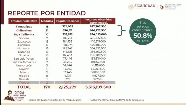
Este martes, la tercera onda de calor de la temporada predominará sobre el territorio nacional, con temperaturas superiores a los 45 grados en zonas de Sinaloa, Michoacán, Guerrero, Morelos, Coahuila, Nuevo León, Tamaulipas, San Luis Potosí, Veracruz, Tabasco, Campeche y Yucatán.
La interacción entre una línea seca y un canal de baja presión sobre el noreste de México, aunados al flujo de la corriente en chorro subtropical, originarán lluvias puntuales fuertes, que podrían originar deslaves, encharcamientos o inundaciones, así como incremento en los niveles de ríos y arroyos; así como descargas eléctricas, posible caída de granizo, rachas de viento de 50 a 70 kilómetros por hora y tolvaneras en zonas de Coahuila, Nuevo León, San Luis Potosí, Zacatecas y Durango, además de la posible formación de torbellinos o tornados en Coahuila, Nuevo León y Tamaulipas.
Canales de baja presión sobre el centro, oriente y sureste mexicano, propiciarán lluvias puntuales fuertes con descargas eléctricas en Chiapas, mismas que podrían originar encharcamientos, deslaves, inundaciones y el incremento en los niveles de ríos y arroyos.